
The Complete Guide to Drone Survey Methodology: From Planning to Delivery
A Blog Post on the complete steps of a Drone Survey.
OPS
2/7/20252 min read
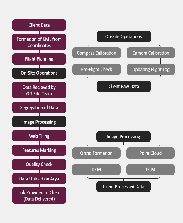
Drone surveys have revolutionized how we collect spatial data, offering unprecedented efficiency and accuracy. In this comprehensive guide, we'll walk through the step-by-step methodology of conducting a professional drone survey, from initial client consultation to final data delivery.
1. Client Data Collection and Initial Planning
The foundation of any successful drone survey begins with thorough client consultation. During this phase:
- Gather specific project requirements
- Define deliverables and expected outcomes
- Identify survey area boundaries
- Discuss timeline and constraints
- Review regulatory requirements and permissions needed
2. Formation of KML from Coordinates
This technical preparation phase involves:
- Converting client-provided boundaries into KML format
- Defining the exact survey area
- Marking no-fly zones and obstacles
- Creating initial flight boundary maps
- Establishing ground control points if needed
3. Flight Planning
Detailed flight planning ensures efficient data collection and includes:
- Calculating optimal flight altitude
- Determining flight paths and overlap requirements
- Setting camera parameters
- Estimating flight time and battery requirements
- Planning for weather conditions
- Identifying backup landing zones
4. On-Site Operations
Field operations require careful preparation and execution:
Compass Calibration
- Performing magnetic interference checks
- Calibrating compass in multiple orientations
- Verifying GPS signal strength
Camera Calibration
- Adjusting camera settings for lighting conditions
- Checking focus and exposure settings
- Verifying image quality
Pre-Flight Check
- Equipment inspection
- Battery status verification
- Weather condition confirmation
- Safety protocol review
Flight Log Updates
- Recording flight parameters
- Documenting environmental conditions
- Noting any anomalies or concerns
5. Data Management
Off-Site Team Reception
- Secure data transfer protocols
- Initial quality assessment
- Backup creation
- Data organization and cataloging
Data Segregation
- Sorting imagery by type
- Organizing flight logs
- Separating calibration data
- Creating processing batches
6. Processing Pipeline
Image Processing
The core technical phase includes:
Ortho Formation
- Generating orthomosaic images
- Correcting geometric distortions
- Color balancing and adjustment
Point Cloud Generation
- Creating dense point clouds
- Filtering and classifying points
- Quality checking point density
DEM (Digital Elevation Model)
- Generating elevation models
- Applying terrain corrections
- Verifying accuracy
DTM (Digital Terrain Model)
- Creating bare earth models
- Removing non-ground objects
- Validating terrain representation
Web Tiling
- Preparing data for web delivery
- Generating zoom levels
- Optimizing for online viewing
Features Marking
- Identifying key elements
- Adding annotations
- Creating GIS layers
7. Quality Assurance
Quality checks are performed at multiple levels:
- Geometric accuracy verification
- Completeness assessment
- Resolution and clarity checks
- Data consistency validation
- Deliverable format verification
8. Data Delivery
Upload to ARU Platform
- Organizing final deliverables
- Applying metadata
- Performing upload verification
- Creating access permissions
Client Delivery
- Generating secure access links
- Providing documentation
- Creating user guides if needed
- Establishing support channels
Best Practices and Tips
1. Always have a pre-flight checklist
2. Monitor weather conditions closely
3. Maintain redundant data backups
4. Document any deviations from the plan
5. Keep detailed processing logs
6. Verify deliverables against requirements
7. Maintain clear communication with clients
Conclusion
A successful drone survey requires careful attention to detail at every stage, from initial planning through final delivery. By following this methodology, surveyors can ensure consistent, high-quality results that meet client needs while maintaining safety and regulatory compliance.
Remember that this workflow may need to be adapted based on specific project requirements, local regulations, and environmental conditions. The key is to maintain flexibility while ensuring all critical steps are completed properly.


Helpful Links
Join Us Online
Want to learn more?
Copyright © Kesowa Infinite Ventures Private Limited
Subscribe to our newsletter for the latest features and updates.
By subscribing, you consent to our Privacy Policy and receive updates.