
RGB and NIR Drone Camera Data: Applications and Use Cases
RGB and Near Infrared Camera applications with Drones.
OPS
2/7/20252 min read
In the rapidly evolving world of drone technology, the combination of RGB (Red, Green, Blue) and NIR (Near-Infrared) cameras has revolutionized how we capture and analyze aerial data. Let's dive into the fascinating world of drone-based multispectral imaging and explore its diverse applications.
Understanding the Technology
RGB Camera
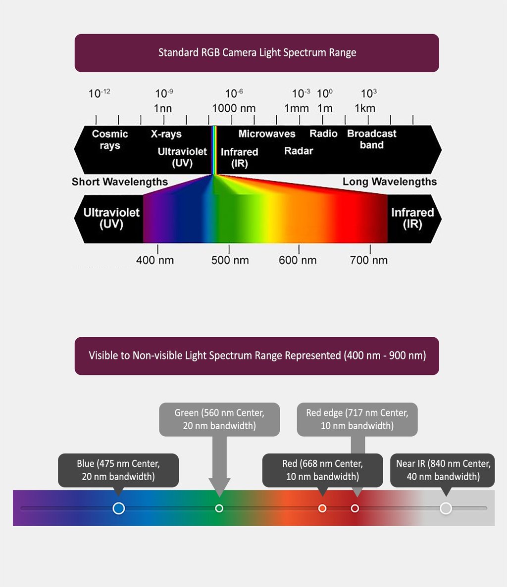
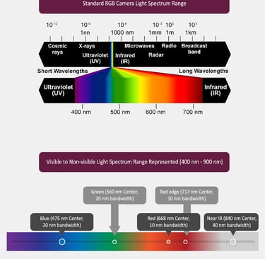
The standard RGB camera captures light in the visible spectrum (400-700nm), similar to how human eyes perceive color. These cameras provide high-resolution images that are crucial for:
- Visual inspection
- 3D modeling
- Orthomosaic mapping
- Asset documentation
NIR Camera
Near-Infrared cameras capture light in the 700-900nm range, just beyond what human eyes can see. NIR imaging is particularly valuable because healthy vegetation strongly reflects NIR light, while stressed vegetation does not.
Data Quality and Resolution
Modern drone-mounted cameras can deliver impressive data quality:
- RGB Resolution: Up to 2.5cm per pixel (20 times higher than standard satellite imagery)
- NIR Sensitivity: Capable of detecting subtle variations in plant health and moisture content
- Combined Analysis: When RGB and NIR data are processed together, they provide rich insights that neither could achieve alone
Key Applications
1. Agriculture and Vegetation Management
- Crop health monitoring through NDVI (Normalized Difference Vegetation Index)
- Early detection of plant diseases
- Irrigation efficiency assessment
- Yield prediction and optimization
- Precise application of fertilizers and pesticides
2. Urban Planning and Development
- Tree canopy assessment
- Green space monitoring
- Heat island effect studies
- Vegetation encroachment tracking
- Urban forest management
3. Environmental Monitoring
- Wetland mapping
- Water quality assessment
- Soil moisture analysis
- Erosion detection
- Habitat mapping and biodiversity assessment
4. Infrastructure Inspection
- Solar panel efficiency monitoring
- Pipeline leak detection
- Power line corridor vegetation management
- Building envelope thermal analysis
- Road and railway corridor assessment
Real-World Use Cases
Case Study 1: Urban Tree Management
A city administration used combined RGB-NIR drone surveys to:
- Create accurate tree inventories
- Assess tree health conditions
- Monitor disease spread
- Plan maintenance schedules
- Calculate carbon sequestration
Case Study 2: Agricultural Optimization
Farmers employed RGB-NIR drone data to:
- Identify areas of crop stress before visible symptoms appeared
- Optimize irrigation schedules
- Reduce fertilizer usage by 15%
- Increase crop yields by targeting interventions
- Monitor crop development throughout the growing season
Best Practices for Data Collection
1. Flight Planning
- Maintain consistent altitude for uniform resolution
- Ensure proper image overlap (75% forward, 65% side)
- Consider sun angle and weather conditions
- Plan flights during optimal times of day
2. Data Processing
- Use appropriate calibration targets
- Apply radiometric corrections
- Implement geometric corrections
- Ensure proper band alignment
- Validate results with ground truth data
Future Developments
The future of RGB-NIR drone imaging looks promising with:
- Advanced AI-powered analysis
- Real-time processing capabilities
- Integration with IoT sensors
- Improved sensor resolution and sensitivity
- Enhanced automated flight capabilities
Conclusion
The combination of RGB and NIR drone camera data provides powerful insights across multiple sectors. As technology continues to advance, we can expect even more innovative applications and improved data quality, making this tool increasingly valuable for decision-makers in various fields.
Whether you're managing urban forests, optimizing agricultural operations, or monitoring environmental changes, RGB-NIR drone imaging offers a unique perspective that can drive better decisions and outcomes. The key lies in understanding both the capabilities and limitations of the technology while following best practices for data collection and analysis.


Helpful Links
Join Us Online
Want to learn more?
Copyright © Kesowa Infinite Ventures Private Limited
Subscribe to our newsletter for the latest features and updates.
By subscribing, you consent to our Privacy Policy and receive updates.