
Monsoon-Proof Your City with Real-Time Drone Surveillance
Monsoon mayhem is predictable—so why suffer it? See how drones turn rain-soaked chaos into data-driven control and calm.
USE-CASE
Rimashree
7/15/20255 min read
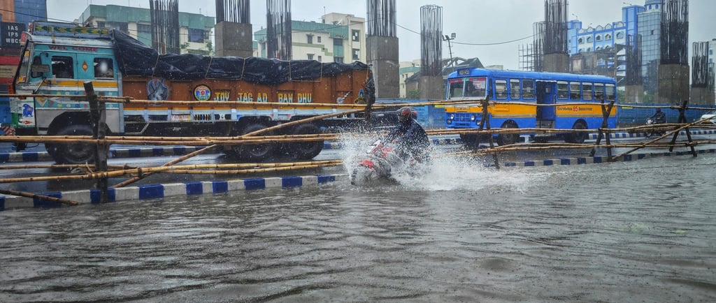
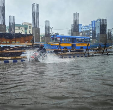
Photo by Dibakar Roy
Monsoons in India are equal parts life-giving and chaos-inducing. While they recharge water tables and fuel agriculture, they also expose the cracks in our urban planning: clogged drains, broken roads and waterlogged colonies. Traditional monitoring systems often fall short when dealing with rapidly changing conditions across vast urban areas.
Enter drone surveillance technology – a game-changing solution that's revolutionizing how cities prepare for, monitor, and respond to monsoon challenges. That’s where Kesowa comes in. As a leader in drone-based data capture and infrastructure intelligence, we help cities see clearly when it matters most. Real-time drone surveillance during monsoons isn’t a luxury. It’s a necessity.
The Monsoon Challenge for Modern Cities
Monsoon seasons present a complex web of challenges for urban planners and emergency responders. Heavy rainfall can overwhelm drainage systems within hours, turning busy streets into dangerous waterways. Critical infrastructure like bridges, underpasses, and low-lying areas become potential disaster zones that require constant monitoring.
Traditional monitoring methods rely heavily on fixed weather stations, CCTV cameras with limited range, and ground-based patrols that become ineffective during severe weather. These systems create dangerous blind spots exactly when cities need comprehensive situational awareness most.
What Drone Surveillance Solves During Monsoon
1. Flood Detection & Mapping in Real-Time
Identify water-logging zones as they form, not after. Our drone footage provides high-resolution, geo-tagged visuals so municipal bodies can quickly dispatch pumps, close roads, and alert citizens.
2. Rapid Damage Assessment
From washed-out roads to collapsed embankments, drones help officials assess structural damage without delay or risk to human life. Aerial data ensures insurance claims, repair estimates, and response planning are grounded in reality.
3. Drainage & Sewer Line Monitoring
Kesowa’s drones equipped with thermal and LIDAR capabilities can detect heat anomalies and subsurface pooling, helping identify blocked or failing stormwater lines before they turn into neighbourhood floods.
4. Urban Planning Intelligence
Monsoon season offers an x-ray of how your city breathes under stress. With drone-generated maps and time-lapse data, urban planners can locate recurring flood zones, illegal encroachments on natural drains, and poor slope grading.
5. Emergency Response Coordination
When it pours, time is everything. Drones deliver live feeds to response teams, helping them prioritize rescue, diversion, and dewatering operations with pinpoint accuracy.
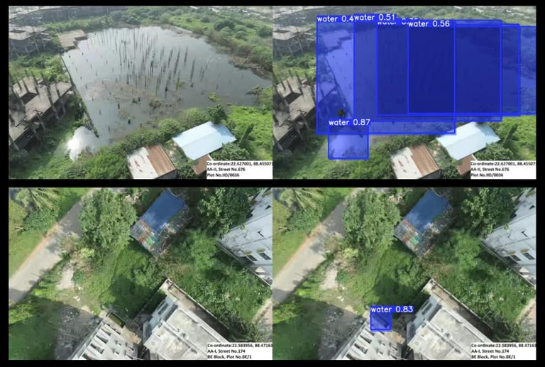
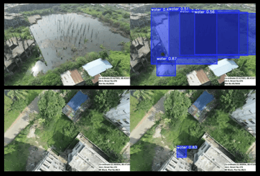

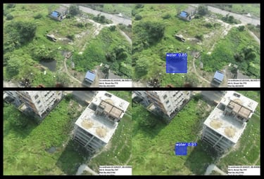
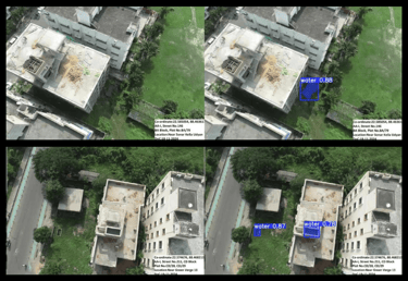
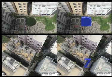
This aerial data of drone imagery showcases AI-powered detection of stagnant water
Why Real-Time Is the Game Changer?
Unlike static CCTV or post-event surveys, drones provide mobility, coverage, and instant analysis. With Kesowa’s cloud-based infrastructure, live data streams directly into a centralized dashboard, empowering city administrators to make data-backed decisions on the fly. Advanced weather-resistant drones form the backbone of effective monsoon surveillance systems. These platforms feature sealed electronics, powerful motors capable of operating in high winds, and extended battery life for prolonged monitoring missions. Many systems incorporate swappable battery technology, allowing for continuous operation throughout severe weather events.
Sensor integration represents another critical component. Multi-spectral cameras can penetrate through rain and low visibility conditions, while thermal sensors detect temperature variations that indicate structural stress or hidden water accumulation. Water level sensors and flow meters provide quantitative data on flood progression and drainage system performance. These systems can automatically identify potential problem areas, predict flood paths based on topographical data, and trigger alerts when predetermined thresholds are exceeded. Pattern recognition technology helps distinguish between normal monsoon conditions and developing emergency situations.
1. Need to reroute traffic from a flooded underpass? Done.
2. Want to measure the rise of water levels in canals? Already mapped.
3. Need to inspect a dam embankment after intense rainfall? We’ll fly it before you finish your tea.
AI for Stagnant Water Detection
Problem & Objective
Stagnant water is a major contributor to the spread of waterborne diseases and acts as a breeding ground for mosquitoes, increasing the risk of outbreaks like dengue and malaria. To address this issue, we developed an AI-based solution for automatic detection of stagnant water from images. The objective was to build a lightweight and accurate model that can identify and localize stagnant water in various environments—urban, rural, and industrial—based on visual cues captured through drone or mobile cameras.
Methodology & Results
We annotated a custom dataset using bounding boxes to mark stagnant water regions and fine-tuned a pre-trained YOLOv8 segmentation model for the object detection task. The model was trained using drone images, with carefully adjusted confidence thresholds and sliding-window inference logic to improve accuracy on high-resolution inputs. We further implemented post-processing to draw bounding boxes with confidence scores. The model successfully generalized to real-world images and can be integrated into municipal inspection tools or mobile-based environmental monitoring systems for early identification of water accumulation.


Real-World Implementation Success Stories
Flood Control in Sector 5, Kolkata (NDITA): Amid rising cases of dengue and increasing instances of waterlogging during the monsoon, the Nabadiganta Industrial Township Authority (NDITA) partnered with Kesowa to map potential breeding grounds for mosquitoes and high-risk flooding zones. A 2 sq. km drone-based orthographic survey was conducted, generating high-resolution maps that were analyzed for water stagnation and drainage inefficiencies. Following this, on-ground teams validated 8 critical hotspots. Targeted interventions were carried out based on Kesowa’s intelligence—leading to significantly improved drainage and a measurable drop in mosquito-borne illnesses.
Monitoring Adi Ganga Encroachment (KMC): The Adi Ganga, once a proud tributary of the Ganges, has suffered from decades of urban encroachment and unchecked pollution. During monsoon season, the canal's compromised capacity exacerbated flooding in adjacent neighborhoods. Kesowa was brought in by the Kolkata Municipal Corporation to conduct a drone survey of key sections of Adi Ganga in Garia. Our drones captured aerial imagery and created GIS vector layers that revealed illegal construction, debris accumulation, and structural vulnerabilities in real time. These insights were critical for urban planners and engineers to develop a long-term restoration and anti-encroachment plan.
Real-Time Urban Surveillance in Newtown (NKDA): In a pioneering move, the Newtown Kolkata Development Authority (NKDA) established a Drone Data Call Center in collaboration with Kesowa. Designed to function like a control room in the sky, the facility receives drone-collected aerial data on infrastructure, traffic, and water systems on a regular basis. During the monsoon, this system has become an invaluable tool for real-time flood tracking, contractor monitoring, and drainage system checks. The ability to stream live footage and access updated maps empowers NKDA to make fast, informed decisions—improving urban resilience and citizen safety.
From Ground Truth to Policy Change
At Kesowa, our drone services don’t stop at data collection. We deliver interpreted analytics, heat maps, 3D terrain models, and post-event comparison reports that can become the foundation of policy upgrades, budget justifications, and climate resilience planning.
So when you monsoon-proof your city, you’re not just surviving a season. You’re future-proofing your infrastructure.
We Fly into the Storm, So You Don’t Have To
Urban flooding is predictable. It’s avoidable. All it takes is a smarter eye in the sky.
Ready to see your city from above this monsoon? Book a free consultation with the Kesowa team today. Ask for a demo on our Monsoon Monitoring Dashboard.
This aerial data of drone imagery showcases AI-powered detection of stagnant water


Helpful Links
Join Us Online
Want to learn more?
Copyright © Kesowa Infinite Ventures Private Limited
Subscribe to our newsletter for the latest features and updates.
By subscribing, you consent to our Privacy Policy and receive updates.