
How a Drone Data Call Centre Revolutionized Aerial Analytics
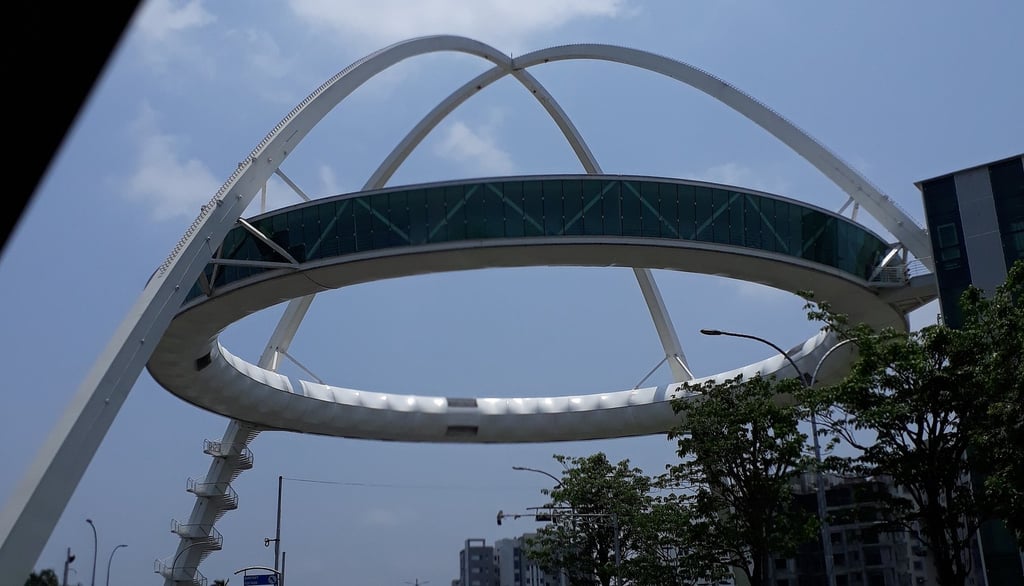
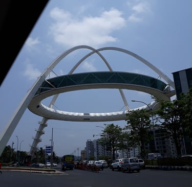
Case Study of Drone Data Call Center (2021 - 2025) at Newtown Kolkata Development Authority, Image by Wikipedia
USE-CASEPRESS
Rimashree | Prayush
3/30/20259 min read
How a Drone Data Call Centre Revolutionized Aerial Analytics
In a world driven by the pursuit of sustainability and smarter living, drones are revolutionizing the landscape of urban management. These sleek, high-tech marvels are not just innovative tools, but game-changers, empowering governments to orchestrate their cities with precision, finesse, and unparalleled efficiency. Imagine a city where traffic flows seamlessly, waste management is automated, infrastructure is monitored in real-time, and emergency response teams arrive faster than ever—all powered by the intelligent eyes of drones in the sky.
What is Drone Data?
Drone data refers to the vast amount of information captured by unmanned aerial vehicles (UAVs) equipped with high-resolution cameras. Every image captured by a drone records the longitude and latitude which enables it to be super imposed on any map. The drone may change based on the mission that it needs to perform - thermal camera for solar panel inspection, spraying unit for water body spraying, speakers for announcement and more.
These drones can provide real-time insights by capturing aerial footage, 3D maps, and environmental metrics. This data is crucial for urban planning, traffic management, infrastructure maintenance, and public safety.
What is a Drone Data Call Centre?
A Drone Data Call Centre is a centralized hub that enables capture, processing, analysis, and interpretation of drone-collected data. By leveraging GIS data with analytical tools and human expertise, the call centre provides real-time reports, alerts, and insights that help city administrators make informed decisions. This innovative solution bridges the gap between drone surveillance and actionable intelligence, ensuring that smart city initiatives are data-driven and efficient.
Recognized as one of India’s premier smart cities, New Town recently earned the prestigious Smart Cities Year Award 2023 for its groundbreaking advancements in urban innovation. Newtown, a rapidly developing urban hub, faced significant issues in monitoring infrastructure, traffic, environmental factors, and public safety. Traditional methods of data collection were slow and inefficient.
To address these challenges, the Drone Data Call Centre was introduced, offering a centralized, AI-assisted solution for processing and analysing drone-generated data in real-time. With AI-assisted traffic management, drone-assisted surveillance, and sustainable infrastructure, the city is setting a new benchmark for efficiency, safety, and eco-friendly urban living.
Top 10 Problem Statements & In-Depth Use Cases over 3 Years
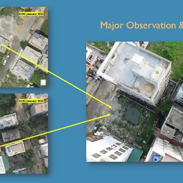
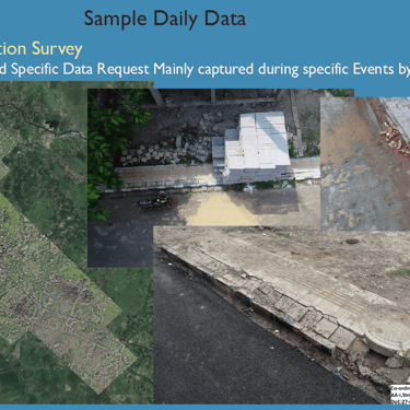
Newtown faced significant challenges in smart city management, which were successfully addressed by drone-based interventions. Below are specific use cases where drones transformed urban governance: (Pictures below the Text)
1. Mosquito Larvae Detection across the Township
• Problem: Stagnant water in constructions sites, water bodies and canals became breeding grounds for mosquito larvae, leading to an increase in diseases like dengue and malaria.
• Solution: RGB Camera equipped drones were deployed with a structured sortie schedule in tandem with ground teams to identify high-risk stagnant water zones and pinpoint breeding areas for timely larvicide treatment. Generation of GIS Heat maps with time series data to create trends and optimize sortie schedule.
• Impact: Vector-borne disease cases reduced by 40%, and mosquito fogging became targeted, saving municipal resources.
2. Stubble Burning Detection
• Problem: Illegal stubble burning led to air pollution, respiratory issues, and environmental degradation.
• Solution: Drones with cameras were flown with a Service Level Agreement to ensure data capture within 1 Hour of Reporting. Generation of GIS Heat maps with time series data to create trends helped to identify burning hotspots, helping authorities take immediate action and fine offenders pro-actively.
• Impact: Data lead to root cause identification of Illegal stubble burning. Air quality improved, with a more than 50% reduction in stubble burning incidents in monitored zones.
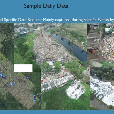
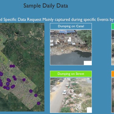
3. Littering, Construction Debris & Waste Dumping Detection
• Problem: Illegal garbage dumping and debris accumulation led to health and sanitation hazards. Despite being a newly built city, there were various reported instances by citizens on cleanliness in the township.
• Solution: Drones detected waste dumping hotspots, allowing for quick cleanups and fines. Monitoring of existing waste collection sites, municipal contractor garbage collection route audit, dark spot identification, construction debris dumping by under construction buildings by Drones for monitoring and corrective action.
• Impact: City cleanliness improved, and waste collection efficiency increased by 30%. Data helped framing of policies.
4. Green Verge & Park Maintenance with Tree Count
• Problem: Lack of proper information of all green verge areas, lack of monitoring led to dark spots, damaged park infrastructure, and unkempt green spaces.
• Solution: Routine Images and Ortho-mosaic maps from Drones enabled to identify actual status of green verges and parks, enabled tracked tree count consistency, gardening contractor work audit, state of public infrastructure, identify encroachment if any along with triggering of actions for upkeep by officers.
• Impact: Remove dark spots, tree survival rates improved by 35%, and park beautification projects became data-driven.
5. Street Light - Blind Spots in Cycling Tracks, Roads, Green Verges and Public Spaces
• Problem: Poorly lit areas on cycling tracks posed safety risks to riders, leading to accidents and reduced usage. Blind spots across the township were prone to increased crime risks.
• Solution: Night-vision drones with Zoom capability conducted dark spot assessments, guiding the placement of streetlights, road infrastructure, parking areas etc, audit operations and maintenance of smart street lights solution supplier. Drone Based GIS Tagged Images enabled digitising existing records into GIS System for future maintenance.
• Impact: Cycling track usage increased by 30%, and accidents reduced by 50% after improved lighting. Reduction in crime reporting from dark areas which now turned bright based on action on Drone Data.
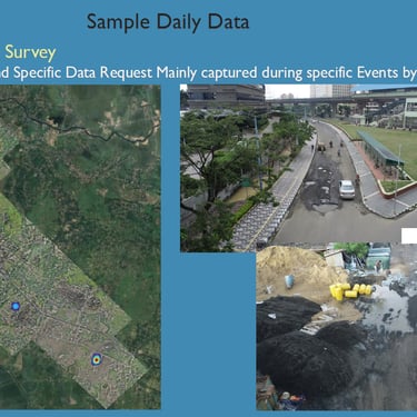
6. Canal Survey & Water Flow Analysis
• Problem: Sediment accumulation and blockages in canals led to flooding and disrupted water flow during rainy season. During cyclone Amphan, a natural disaster, canals overflowed creating major unrest to residents nearby. Unmonitored growth of water hyacinth lead to creating larvae mosquito breeding grounds in canals which lead to increased health risks. Only 20% of Canals accessible on foot/ vehicles for inspection.
• Solution: Drones equipped with advanced imaging technology, combined with GIS map data, were utilized to conduct linear route surveys and capture critical data. More than 30 canals, were surveyed every quarter – drone is flown at the same height and same angle allowing for time series data analysis.
• Impact: Flood preparedness improved by 60%, and canal maintenance costs decreased.
7. Traffic Signal Monitoring, Road Survey & Maintenance Planning
• Problem: Delayed identification of potholes and cracks led to increased repair costs and accidents.
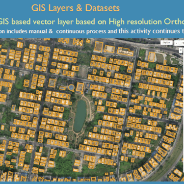
• Solution: AI-assisted road condition surveys helped prioritize repair schedules. Before/ After Drone Inspections of road stretches where ROW permission was allowed by Urban Local Body; Before/ After Drone Inspections of road stretches where municipal funds were sanctioned and spent for road construction and repair; Drone Inspections of new routes, roads to be widened; traffic signal point monitoring, new traffic signal point installation survey; GIS Data creation – accurate vector layers from Drone based maps; are some of the use cases.
• Impact: Road repair efficiency improved by 45%, preventing accidents and reducing costs.
8. Footpath Condition & Encroachment Survey
• Problem: Uneven and broken footpaths were hazardous to pedestrians, especially the elderly and disabled. Encroachment in numerous areas on footpaths lead to revenue losses and increased jaywalking.
• Solution: High-resolution imagery identified damaged pathways, allowing for proactive maintenance, re-organise hawkers to structured local markets, remove unlicensed hawkers and encroachment, contractor audit, monitoring of road beautification projects.
• Impact: Pedestrian accessibility improved, and footpath repairs became 50% faster.
9. Open Manhole Survey
• Problem: Unattended open manholes posed serious risks to vehicles and pedestrians.
• Solution: Drones identified open or damaged manholes, triggering immediate repair requests.
• Impact: 80% faster manhole repairs, preventing accidents and injuries.
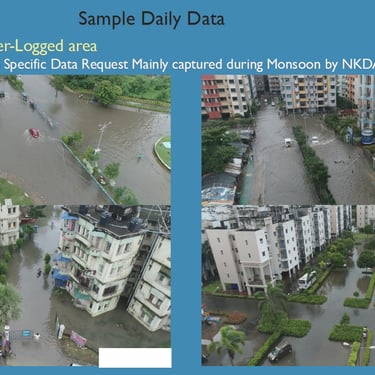
10. Water Logging Survey
• Problem: Poor drainage systems caused urban flooding during rainy seasons, disrupting daily life.
• Solution: Aerial mapping of low-lying flood-prone areas helped authorities optimize drainage systems. GIS Tagged images superimposed on Storm Water Drainage Network maps lead to identification of root causes such as blocking of specific stretches of drains, construction debris blocking, need of upgrading specific drain stretches and more.
• Impact: Waterlogging incidents reduced by 50%, improving urban mobility.
3 Special Mentions apart from the Top 10 Use Cases which we have to mention
1. Solar Panel Monitoring
• Problem: Solar Panels were installed on top of canals, specific buildings, street lights which were not being monitoring. Dust and bird droppings reduced solar panel efficiency by 20-30%.
• Solution: Thermal drones detected hotspots indicating inefficiencies, allowing for precise cleaning schedules.
• Impact: Solar power output increased by 15%, and maintenance costs reduced by 25%.
2. Construction Progress Monitoring
• Problem: Key Officials such as CEO, City Architects, Project Managers, Engineers of Building Department struggled to track project progress, sanction vs completion status of plots, leading to delays and cost overruns.
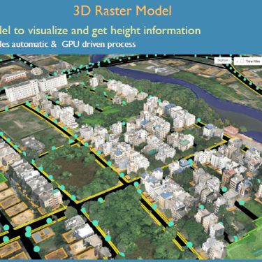
• Solution: High-resolution aerial scans provided progress reports, 3D mapping, and compliance tracking.
• Impact: Faster approval of Sanction and Extension of Sanction Plan, Project delays reduced by 40%, and investors gained transparent real-time updates.
3. Public Map of Newtown
• Problem: Residents of Newtown were unclear on which Action Area/ Ward was their residence in, which Police Station did they have to visit to report a complain, which PIN Code was theirs’.
• Solution: Digitised Public Map Mission created with Vector Layers clarifying area, police station, and PIN code for each plot. Further more, over time each plot was accurately digitsed and vector layers were made public with specific fields allowing complete transparency.
• Impact: Improved record accessibility of public records by residents and visitors of Newtown.
Implementation & Workflow
How does the Drone Data Call Centre transform aerial surveillance into actionable urban intelligence? It’s a seamless four-step process that ensures Newtown stays one step ahead in smart city governance.
Step 1: Drone Deployment
Autonomous drones take flight over Newtown, capturing high-resolution images, and thermal data. Equipped with advanced sensors, they meticulously map out infrastructure, monitor traffic patterns, and track environmental changes. Route planning, Workflow automation, Take Off/ Landing Location Intelligence are some of the factors enabling successful mission operations.
Step 2: Data Transmission
The captured data is instantly relayed to the Remote Station. With high-speed connectivity, the Drone Data Call Centre receives a continuous stream of real-time visual and sensory information or offline as required, ready for immediate processing.
Step 3: Processing & Analysis
Here’s where the magic happens. GIS data and analytical tools were employed to scan for anomalies, detect patterns, and classify critical data points. Whether it's a pothole forming on a main road, illegal waste dumping, or rising pollution levels, the system flags issue instantly. Human analysts then validate the insights generated from the GIS analysis, ensuring accuracy before alerts are sent out for timely intervention and maintenance.
Step 4: Actionable Insights & Decision-Making
Once processed, the data is transformed into comprehensive reports, heatmaps, and predictive analytics dashboards. Authorities receive instant alerts, enabling quick decision-making—from dispatching repair teams to redirecting traffic or initiating emergency responses.
The result? A faster, smarter, and more proactive urban management system.
Results and Impact
In just 4 years, our Drone Call Centre revolutionized how Newtown Kolkata Development Authority manages its 56 sq. km jurisdiction:
• 2,442 missions completed, including 1,233 high-resolution mapping projects.
• 100% compliance with 1-hour emergency response time across 120 critical missions.
• ₹2000+ Crore worth of development projects effectively monitored.
• 99.8% operational reliability with minimal incidents.
• 85% reduction in survey turnaround time compared to traditional methods
These achievements have led to:
• Enhanced disaster response capabilities, allowing authorities to act swiftly during emergencies.
• Greater urban planning efficiency, with real-time data enabling better infrastructure investments.
• Reduced environmental risks, through consistent monitoring of pollution levels and mosquito breeding grounds.
• Cost savings and improved budget allocation, as drone intelligence minimizes redundant field surveys.
• Improved citizen engagement, as real-time insights are used to create transparent governance and better public services.
From reactive troubleshooting to proactive policy implementation, our drone intelligence platform has evolved into an essential component of NKDA's governance framework.
Future Outlook
The future of Newtown’s Drone Data Call Centre is poised for technological expansion and broader impact:
Improved Public Map
With 3D Digital Twins of Parks being made public, to potential projects being planned made public for stakeholder consultation – residents dialogue will lead to improved public maps. Integration of Third Party Data like Health Data, Air Quality Sensor Data, Weather Data can help frame policy on city level design interventions to meet standardised goals.
Drone Data Submission to Public Platforms and Stakeholder Teams
As cities look at tools like Zoning to boost revenues, Drone Data can help create actual as on date baseline in the absence of as-built-maps. City soft infrastructure like public spaces, roads, powerlines, water and waste water network, internet and telecom infrastructure planning and maintenance can be simplified with data sharing.
AI-Driven Automation for Predictive Maintenance
Future upgrades will integrate advanced AI algorithms capable of predicting infrastructure failures before they occur. Roads, bridges, and drainage systems will receive preventative maintenance alerts, reducing costly repairs and improving urban resilience.
Expanding Beyond Newtown: Scaling to Other Smart Cities
The success of Newtown’s Drone Data Call Centre serves as a blueprint for replication. Other cities facing similar urban challenges can adopt this model, leveraging AI-assisted drone intelligence to transform their infrastructure, traffic management, and environmental monitoring.
Mini ATC and Introduction of Cargo and Passenger Drones
With the framework set for field operations, Newtown can look at spearhead and adopt leading practices to establish Mini ATC for Airspace Management. With infrastructure support, Introduction of Cargo Drones for Beyond Visual Line of Sight Operations can pave way for adoption of Passenger Drones by 2030.
Conclusion
The implementation of the Drone Data Call Centre in Newtown has revolutionized smart city management, offering real-time insights and predictive analytics to enhance infrastructure, transportation, environmental sustainability, and security.
As cities continue to evolve, leveraging drone technology and AI-assisted analytics will become essential for efficient and data-driven urban planning.


Helpful Links
Join Us Online
Want to learn more?
Copyright © Kesowa Infinite Ventures Private Limited
Subscribe to our newsletter for the latest features and updates.
By subscribing, you consent to our Privacy Policy and receive updates.