
Drone Survey Helps Visualize Vedanta Wisdom Trust's University Campus in the Western Ghats
3D Drone Survey for University during land procurement and planning stage.
USE-CASE
3/15/20252 min read
In late October 2024, our team at Kesowa conducted a comprehensive drone survey for Vedanta Wisdom Trust's upcoming university campus project in Chinchwali Tarf Atone, Raigad District. Located in the picturesque Western Ghats about 124 kilometers from Mumbai, this site presented unique opportunities and challenges for aerial documentation.
Location and Accessibility
The project site is strategically located just 11.1 kilometers from Kolad Railway Station via NH66, making it accessible while maintaining the serenity needed for an educational institution. The surroundings feature notable landmarks including the Kundalika River, Surgad Fort, and Surgad Waterfall, creating an inspiring natural environment for learning.
Comprehensive Aerial Documentation
Our survey utilized multiple drone technologies to capture:
1. High-resolution aerial photographs showing the terrain's natural contours
2. Detailed videography of the entire property
3. Orthographic mapping with 2.5cm/pixel resolution
4. 3D terrain modeling with elevation data
5. Digital Surface Models (DSM) integrated with the master plan
Key Findings
The aerial survey revealed several interesting aspects of the property:
- Natural Landscape: The site features gently rolling hills covered with native vegetation, offering natural terracing opportunities for campus development
- Water Resources: The property has excellent views of the Kundalika River, with water bodies visible from the southern edge
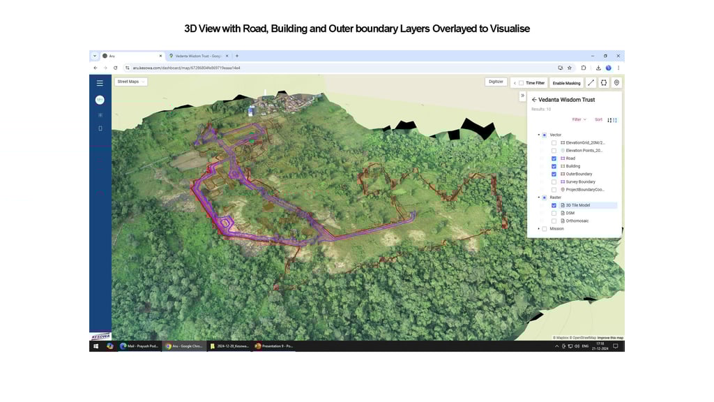
- Existing Infrastructure: Our 3D mapping identified existing access roads and building locations, crucial for integration with new development plans
Technical Innovation
What made this survey particularly valuable was our ability to overlay the architect's master plan onto the drone-captured imagery. Using our ARU (A Real Understanding) platform, we created interactive 3D visualizations that allow stakeholders to:
- Toggle between different layers (roads, buildings, boundaries)
- View the site from multiple angles
- Understand how proposed structures will integrate with the natural topology
- Assess environmental impact and preservation areas
Impact on Project Planning
The drone survey has proven invaluable for the trust's planning process. By providing accurate, detailed visualization of how the campus will sit within the landscape, stakeholders can make informed decisions about:
- Building placement and orientation
- Access road optimization
- Environmental conservation areas
- Infrastructure planning
- Construction phasing
This project exemplifies how drone technology can bridge the gap between architectural vision and natural reality, especially in environmentally sensitive areas like the Western Ghats. The resulting data will help ensure the university campus develops in harmony with its surroundings while meeting its educational objectives.
The survey deliverables include orthomosaic maps, 3D models, and interactive visualizations that will continue to serve as valuable references throughout the project's development phases.
This blog post is based on a drone survey conducted by Kesowa in October 2024 for Vedanta Wisdom Trust.


Helpful Links
Join Us Online
Want to learn more?
Copyright © Kesowa Infinite Ventures Private Limited
Subscribe to our newsletter for the latest features and updates.
By subscribing, you consent to our Privacy Policy and receive updates.