
ARU Server: Revolutionizing 3D Visualization for AEC Professionals
Announcing 3D Visualization, Feature Update 2
ARU-SOFTWARE
2/7/20252 min read
ARU Server: Revolutionizing 3D Visualization for AEC Professionals
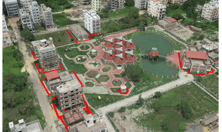
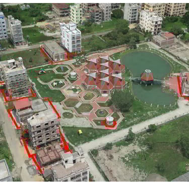
We're thrilled to announce a game-changing update to ARU Server that transforms how Architecture, Engineering, and Construction (AEC) professionals interact with 3D data. Our latest feature brings powerful 3D file visualization capabilities, complete with seamless AutoCAD drawing and vector layer superimposition.
Breaking New Ground in 3D Visualization
The new ARU Server update introduces an intuitive 3D visualization engine that allows users to:
- Import and render complex 3D models with high performance
- Superimpose AutoCAD drawings directly onto 3D models
- Overlay vector layers for enhanced spatial understanding
- Navigate through models in real-time with smooth performance
- Compare as-built conditions with design specifications
Transforming AEC Workflows
For AEC professionals, this update bridges the crucial gap between design and reality. Imagine being able to:
- Overlay building information models (BIM) with drone-captured point clouds
- Compare construction progress against original plans in 3D space
- Identify discrepancies between design and implementation instantly
- Collaborate with team members through shared 3D visualization sessions
- Document and track changes throughout the project lifecycle
Real-World Applications
The applications of this technology extend far beyond traditional construction:
Urban Planning
- Visualize proposed developments within existing city models
- Assess impact on skylines and sight lines
- Analyze shadow studies and environmental impact
Historic Preservation
- Document existing structures in detailed 3D
- Plan restoration work with precision
- Archive historical buildings digitally
Infrastructure Development
- Monitor bridge and tunnel construction progress
- Track road and railway alignment accuracy
- Verify compliance with design specifications
Technical Excellence Meets Usability
While powerful, the new feature maintains ARU's commitment to user-friendly design:
- Intuitive controls for 3D navigation
- Simple drag-and-drop file import
- Automatic layer organization
- Real-time collaboration capabilities
- Cloud-based processing for optimal performance
Beyond Construction
The implications of this update reach beyond the AEC industry:
- Mining operations can compare excavation progress against plans
- Manufacturing facilities can verify equipment placement and clearances
- Urban planners can assess development impact more effectively
- Real estate developers can visualize projects before breaking ground
Looking Forward
This release marks a significant milestone in our mission to deliver comprehensive drone data solutions. By combining accurate 3D visualization with existing ARU capabilities, we're creating a more connected, efficient, and precise working environment for professionals across industries.
Ready to experience the future of 3D visualization? Contact our team to schedule a demo or upgrade your existing ARU Server installation.
ARU Server's new 3D visualization features are available now for all enterprise customers. Contact sales@kesowa.com for pricing and implementation details.


Helpful Links
Join Us Online
Want to learn more?
Copyright © Kesowa Infinite Ventures Private Limited
Subscribe to our newsletter for the latest features and updates.
By subscribing, you consent to our Privacy Policy and receive updates.